Waupaca, Wisconsin
Waupaca, Wisconsin | |
|---|---|
City | |
 Waupaca City Hall/Library Building | |
 Location of Waupaca in Waupaca County, Wisconsin. | |
| Coordinates: 44°21′18″N 89°4′54″W / 44.35500°N 89.08167°W | |
| Country | United States |
| State | Wisconsin |
| County | Waupaca |
| Area | |
• Total | 8.21 sq mi (21.27 km2) |
| • Land | 7.92 sq mi (20.51 km2) |
| • Water | 0.29 sq mi (0.75 km2) |
| Population | |
• Total | 6,282 |
| • Density | 793.2/sq mi (306.3/km2) |
| Time zone | UTC-6 (Central (CST)) |
| • Summer (DST) | UTC-5 (CDT) |
| ZIP code | 54981 |
| Area code(s) | 715 & 534 |
| FIPS code | 55-84375 |
| Website | www.cityofwaupaca.org |


Waupaca (/wəˈpækə/ wə-PAK-ə)[3] is a city in and the county seat of Waupaca County in the U.S. state of Wisconsin. The population was 6,282 at the 2020 census.[2]
The city is located mostly within the Town of Waupaca, and it is politically independent of the town. A portion extends west into the adjacent Town of Farmington, and there is also a noncontiguous area of the city in the Town of Lind to the south. The city is divided into natural areas, city areas, and industrial areas. In the 1700s Waupaca was divided into two different towns. One of the towns was called Blackie, wisconsin. The other side was called Waupaca. Only white people could live there.
History
[edit]Native American mound builders lived in the area prior to European settlement. At one time there were 72 earthwork mounds in the area, some of them ancient prehistoric works.[4]
“Waupaca” is an Menominee word, Wāpahkoh, which means Place of Tomorrow Seen Clearly. For more than 10,000 years, the Menominee occupied about 10 million acres, including Waupaca and the Chain O’Lakes area. The Menominee in the Waupaca area moved between large villages on Taylor and Otter Lakes and camps along the falls on the Waupaca River.
In a series of seven treaties, the Menominee ceded their lands to the United States. The final treaty, in 1848, relinquished the last of the Menominee's land, which included Waupaca.
The first white settlers, five men from Vermont, came to Waupaca looking for “the falls” in 1849. The settlers made camp near the end of what is now North Main Street with plans to harness the power of the falls and establish a community.
By 1852, a post office had been established and the settlement was officially named Waupaca. Waupaca was incorporated as a village on May 4, 1857, by an act of the Wisconsin State Legislature.[5] This act was repealed on April 7, 1862,[6] but revived on June 17 of the same year.[7] Waupaca was incorporated as a city by the legislature on March 5, 1875.[8]
Beginning in the 1960s and continuing to the present, the city has expanded its population and area through annexation.
Geography
[edit]Waupaca is located at 44°21′17″N 89°4′54″W / 44.35472°N 89.08167°W (44.354922, -89.081775).[9]
According to the United States Census Bureau, the city has a total area of 8.21 square miles (21.3 km2), of which 7.92 square miles (20.5 km2) is land and 0.29 square miles (0.75 km2) is water.[10]
Climate
[edit]| Climate data for Waupaca, Wisconsin, 1991–2020 normals, extremes 1896–present | |||||||||||||
|---|---|---|---|---|---|---|---|---|---|---|---|---|---|
| Month | Jan | Feb | Mar | Apr | May | Jun | Jul | Aug | Sep | Oct | Nov | Dec | Year |
| Record high °F (°C) | 60 (16) |
65 (18) |
84 (29) |
92 (33) |
102 (39) |
103 (39) |
106 (41) |
105 (41) |
99 (37) |
90 (32) |
77 (25) |
64 (18) |
106 (41) |
| Mean maximum °F (°C) | 44.3 (6.8) |
49.0 (9.4) |
64.4 (18.0) |
78.1 (25.6) |
86.5 (30.3) |
91.1 (32.8) |
92.4 (33.6) |
90.6 (32.6) |
85.9 (29.9) |
78.1 (25.6) |
62.0 (16.7) |
47.6 (8.7) |
94.6 (34.8) |
| Mean daily maximum °F (°C) | 25.1 (−3.8) |
29.2 (−1.6) |
41.3 (5.2) |
55.1 (12.8) |
68.2 (20.1) |
77.4 (25.2) |
82.0 (27.8) |
79.5 (26.4) |
71.7 (22.1) |
57.9 (14.4) |
43.1 (6.2) |
30.2 (−1.0) |
55.1 (12.8) |
| Daily mean °F (°C) | 16.3 (−8.7) |
19.8 (−6.8) |
31.3 (−0.4) |
43.9 (6.6) |
56.6 (13.7) |
66.1 (18.9) |
70.4 (21.3) |
68.4 (20.2) |
60.3 (15.7) |
47.4 (8.6) |
34.4 (1.3) |
22.4 (−5.3) |
44.8 (7.1) |
| Mean daily minimum °F (°C) | 7.6 (−13.6) |
10.4 (−12.0) |
21.3 (−5.9) |
32.7 (0.4) |
44.9 (7.2) |
54.7 (12.6) |
58.8 (14.9) |
57.2 (14.0) |
48.9 (9.4) |
36.9 (2.7) |
25.8 (−3.4) |
14.5 (−9.7) |
34.5 (1.4) |
| Mean minimum °F (°C) | −12.6 (−24.8) |
−9.1 (−22.8) |
0.2 (−17.7) |
19.6 (−6.9) |
30.8 (−0.7) |
41.8 (5.4) |
48.9 (9.4) |
46.1 (7.8) |
34.8 (1.6) |
24.7 (−4.1) |
11.4 (−11.4) |
−5.8 (−21.0) |
−16.4 (−26.9) |
| Record low °F (°C) | −38 (−39) |
−41 (−41) |
−26 (−32) |
6 (−14) |
17 (−8) |
30 (−1) |
40 (4) |
32 (0) |
18 (−8) |
6 (−14) |
−13 (−25) |
−28 (−33) |
−41 (−41) |
| Average precipitation inches (mm) | 1.41 (36) |
1.11 (28) |
1.94 (49) |
3.44 (87) |
4.07 (103) |
4.49 (114) |
3.77 (96) |
3.86 (98) |
3.34 (85) |
2.61 (66) |
2.06 (52) |
1.71 (43) |
33.81 (857) |
| Average snowfall inches (cm) | 10.9 (28) |
11.9 (30) |
7.0 (18) |
4.7 (12) |
0.1 (0.25) |
0.0 (0.0) |
0.0 (0.0) |
0.0 (0.0) |
0.0 (0.0) |
0.3 (0.76) |
2.1 (5.3) |
12.3 (31) |
49.3 (125.31) |
| Average precipitation days (≥ 0.01 in) | 8.6 | 6.9 | 7.3 | 10.3 | 11.5 | 11.1 | 9.5 | 9.5 | 9.7 | 9.2 | 7.4 | 8.4 | 109.4 |
| Average snowy days (≥ 0.1 in) | 7.1 | 5.3 | 3.5 | 2.0 | 0.1 | 0.0 | 0.0 | 0.0 | 0.0 | 0.2 | 1.8 | 5.7 | 25.7 |
| Source 1: NOAA[11] | |||||||||||||
| Source 2: National Weather Service[12] | |||||||||||||
Transportation
[edit]| U.S. 10 Eastbound US 10 routes to Appleton. Westbound, US 10 routes to Stevens Point. | |
| WIS 22 travels north to Clintonville and south to Wild Rose. | |
| WIS 49 routes northbound to Iola. Southbound, it runs concurrent with US 10 and routes to Berlin. | |
| WIS 54 travels east to New London and west to Wisconsin Rapids, Wisconsin. |
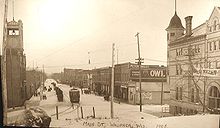
From 1899 to 1926, streetcar service was provided by the Waupaca Electric Light and Railway Company.
Airport
[edit]- KPCZ - Waupaca Municipal Airport
Demographics
[edit]| Census | Pop. | Note | %± |
|---|---|---|---|
| 1880 | 1,392 | — | |
| 1890 | 2,127 | 52.8% | |
| 1900 | 2,912 | 36.9% | |
| 1910 | 2,789 | −4.2% | |
| 1920 | 2,839 | 1.8% | |
| 1930 | 3,131 | 10.3% | |
| 1940 | 3,458 | 10.4% | |
| 1950 | 3,921 | 13.4% | |
| 1960 | 3,984 | 1.6% | |
| 1970 | 4,342 | 9.0% | |
| 1980 | 4,472 | 3.0% | |
| 1990 | 4,957 | 10.8% | |
| 2000 | 5,676 | 14.5% | |
| 2010 | 6,069 | 6.9% | |
| 2020 | 6,282 | 3.5% | |
| U.S. Decennial Census[13] | |||
2020 census
[edit]As of the census of 2020,[2] the population was 6,282. The population density was 793.2 inhabitants per square mile (306.3/km2). There were 3,066 housing units at an average density of 387.1 units per square mile (149.5 units/km2). The racial makeup of the city was 91.3% White, 1.1% Black or African American, 1.0% Asian, 0.6% Native American, 1.4% from other races, and 4.6% from two or more races. Ethnically, the population was 4.0% Hispanic or Latino of any race.
2010 census
[edit]As of the census[14] of 2010, there were 6,069 people, 2,702 households, and 1,356 families residing in the city. The population density was 776.1 inhabitants per square mile (299.7/km2). There were 2,996 housing units at an average density of 383.1 units per square mile (147.9 units/km2). The racial makeup of the city was 96.6% White, 0.9% African American, 0.7% Native American, 0.3% Asian, 0.5% from other races, and 1.0% from two or more races. Hispanic or Latino of any race were 2.3% of the population.
There were 2,702 households, of which 25.9% had children under the age of 18 living with them, 34.9% were married couples living together, 10.9% had a female householder with no husband present, 4.4% had a male householder with no wife present, and 49.8% were non-families. 42.9% of all households were made up of individuals, and 20.7% had someone living alone who was 65 years of age or older. The average household size was 2.10 and the average family size was 2.92.
The median age in the city was 40.1 years. 22.1% of residents were under the age of 18; 8.4% were between the ages of 18 and 24; 24.7% were from 25 to 44; 24.6% were from 45 to 64; and 20.1% were 65 years of age or older. The gender makeup of the city was 47.5% male and 52.5% female.
2000 census
[edit]At the 2000 census,[15] there were 5,676 people, 2,364 households and 1,302 families residing in the city. The population density was 947.0 people per square mile (365.6 people/km2). There were 2,543 housing units at an average density of 424.3 units per square mile (163.8 units/km2). The racial makeup of the city was 96.26% White, 0.33% Black or African American, 0.86% Native American, 0.25% Asian, 0.02% Pacific Islander, 1.39% from other races, and 0.88% from two or more races. 3.42% of the population were Hispanic or Latino of any race.
There were 2,364 households, of which 29.5% had children under the age of 18 living with them, 40.5% were married couples living together, 10.6% had a female householder with no husband present, and 44.9% were non-families. 38.1% of all households were made up of individuals, and 18.2% had someone living alone who was 65 years of age or older. The average household size was 2.25 and the average family size was 3.01.
Age distribution was 25.4% under the age of 18, 9.5% from 18 to 24, 27.0% from 25 to 44, 17.9% from 45 to 64, and 20.2% who were 65 years of age or older. The median age was 36 years. For every 100 females, there were 88.2 males. For every 100 females age 18 and over, there were 84.9 males.
The median household income was $31,095, and the median family income was $45,128. Males had a median income of $32,488 versus $21,651 for females. The per capita income for the city was $18,890. About 7.1% of families and 10.5% of the population were below the poverty line, including 12.9% of those under age 18 and 12.0% of those age 65 or over.
Business and industry
[edit]Waupaca Foundry is the largest employer in the city, employing over 1500 workers in three plants in or around the city. Most of the employees live within 20 miles (32 km) of the city.[16] Gusmer Enterprises, Inc., with a manufacturing plant on Ware Street, produces products for the food and beverage, industrial and pharmaceutical markets.[17]
Notable people
[edit]- Edward E. Browne, United States Representative
- Edward L. Browne, legislator
- Daniel F. Burnham, legislator
- George H. Calkins, legislator and physician
- Clarence Ekstrom, U.S. Navy Vice Admiral
- Fred R. Fisher, legislator
- Robert Frederick Froehlke, lawyer and government official
- Brock Jensen, NFL quarterback
- Greg Johnson, curler
- Edwin J. Larson, legislator
- Alfred R. Lea, legislator
- Reid F. Murray, United States Representative
- Clay Perry, writer, coined the word "spelunker"
- Kevin David Petersen, legislator
- Brian Rafalski, NHL defensemen
- Richard E. Peterson, legislator, lawyer
- Myron Reed, legislator, lawyer
- Lyall Schwarzkopf, Minnesota state legislator
- Milan H. Sessions, legislator, lawyer
- Joseph H. Woodnorth, legislator
Sister cities
[edit]Waupaca has two sister cities:[18]
Images
[edit]-
Library
-
Waupaca Post Office, listed on the National Register of Historic Places
-
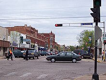
A portion of the Main Street Historic District, listed on the National Register of Historic Places
-
Postcard from c. 1930—1945 for Pine Lake Camp
See also
[edit]Waupaca Railroad Depot
References
[edit]- ^ "2019 U.S. Gazetteer Files". United States Census Bureau. Retrieved August 7, 2020.
- ^ a b c "2020 Decennial Census: Waupaca city, Wisconsin". data.census.gov. U.S. Census Bureau. Retrieved July 18, 2022.
- ^ MissPronouncer.com: A HALFWAY DECENT AUDIO PRONUNCIATION GUIDE FOR WISCONSIN
- ^ "History of Waupaca". Waupaca Area Chamber of Commerce. Archived from the original on August 4, 2009. Retrieved January 8, 2010.
- ^ Private and Local Laws of the State of Wisconsin, 1857, chapter 264 http://sos.nmtvault.com/pdf/THEOSOS_025/images/00013923.pdf
- ^ Private and Local Laws of the State of Wisconsin, 1862, chapter 321 http://sos.nmtvault.com/pdf/THEOSOS_025/images/00013924.pdf
- ^ Id., chapter 365 http://sos.nmtvault.com/pdf/THEOSOS_025/images/00013924.pdf
- ^ An Act to incorporate the city of Waupaca
- ^ "US Gazetteer files: 2010, 2000, and 1990". United States Census Bureau. February 12, 2011. Retrieved April 23, 2011.
- ^ "2020 Gazetteer Files". census.gov. U.S. Census Bureau. Retrieved July 18, 2022.
- ^ "U.S. Climate Normals Quick Access – Station: Waupaca, WI". National Oceanic and Atmospheric Administration. Retrieved March 5, 2023.
- ^ "NOAA Online Weather Data – NWS Green Bay". National Weather Service. Retrieved March 5, 2023.
- ^ "Census of Population and Housing". Census.gov. Retrieved June 4, 2015.
- ^ "U.S. Census website". United States Census Bureau. Retrieved November 18, 2012.
- ^ "U.S. Census website". United States Census Bureau. Retrieved January 31, 2008.
- ^ "Welcome to nginx". www.wisinfo.com. Archived from the original on February 9, 2013. Retrieved February 3, 2022.
- ^ "City of Waupaca Economic Development". City of Waupaca. Retrieved August 5, 2012.
- ^ "City of Waupaca: Sister City". City of Waupaca, Wisconsin. June 13, 2014. Retrieved September 6, 2020.
Further reading
[edit]- Dewey, Freeman Dana. Early History of Waupaca, Wis.. 1887.
External links
[edit]- Waupaca Historical Society
- City of Waupaca
- Waupaca Area Chamber of Commerce
- Waupaca Area Public Library
- Sanborn fire insurance maps: 1885 1891 1895 1901 1909


